
Plague Quarantine Page Menu: 1 2 3 4 5 6 7 8 9 10 11 12 13 14 15 <<First
Golden Age of Piracy Maritime Quarantine For Plague, Page 15
The English Quarantine Stations
The history of quarantine stations in England is somewhat reminiscent of the way land-based lazarettos were established in the Mediterranean. Just as the land-based 'temporary' lazarettos were set up when the plague was present at a location, so England used quarantine intermittently, during times of plague in the country or when the nation felt threatened by the plague being present at one of the countries with which they traded. Historian John Booker explains, "until 1754 quarantine was not a continuous legal requirement" in England.1 Nor did England ever fully establish any permanent maritime lazarettos. When Dutch ships were recommended to be be quarantined in 1663 and 1664, an "attempt to find space for a lazaretto (quarantine station) and airing ground clearly failed, and the emphasis changed to quarantine pure and simple."2 The only lazaretto to be built England was constructed in Stangate Creek long after the end of the golden age of piracy in the early nineteenth century, "but it was subsequently abandoned and the materials sold for a fraction of their cost."3

English Quarantine Locations During the Golden Age of Piracy, Information From John Booker,
Maritime
Quarantine: The British Experience c. 1650 -1900, 2007, p. 574
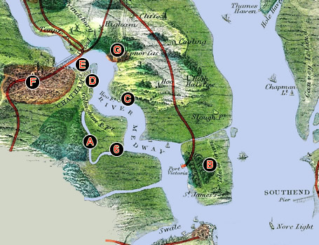
Quarantine in England was performed by sending a ship to a location referred to as a 'station' where they were to anchor and serve the period of quarantine assigned to their ship. Historian John Booker points out that "virtually any port, particularly in the south-west of England, could be used occasionally and unofficially for quarantine purposes, usually because the condition of the ship or state of the weather made it arguably dangerous to proceed to the appointed place"4. Booker identifies several locations which were assigned to be used for quarantine purposes. Those which he indicates were active during the golden age of piracy (or just before it in one case) are shown on the map seen at left.
The first thing that is notable about all of these locations is that they are near large cities. Just as Mediterranean lazarettos were located near large cities. usually outside their city limits, so the English picked similar locations. The places in use show on this map include: (1) Holehaven Creek (1663-4 & 1668-9), (2) The Hope/Hope Reach (1692-3), (3) Harwich (1709-14), (4) Motherbank (1709-c.1895), (5) Newcastle (1709-14), (6) Stangate Creek (1709-c.1870), about nine miles from Rochester, (7) Whitebooth Road (1660-c. 1850), about nine miles from Hull, (8) Bristol (1720-c.1850), (9) St. Just's Pool (1720-c.1850), about three miles from Falmouth and (10) Plymouth (1720 - c.1850).5
Historical information about most of the locations used to quarantine ships in England is limited. Writing in 1894, Charles Creighten explained, "I had purposed including a history of quarantine in Britain, but can find no convenient context for it."6 (He then suggests readers consult the Encyclopedia Britannica for more on the topic.) As a result, much of the information about these locations comes from John Booker's tome which he assembled by combing the official records in the British Archives. While these contain a great deal of information, they generally do not describe the quarantine locations in detail. However, some observations can still be made based on this information. Not surprisingly, all of these locations are fairly desolate, something that would have accommodated quarantine. However, this meant that posted guards were necessary to see that proper quarantine procedures were observed.
1 John Booker, Maritime Quarantine: The British Experience c. 1650 -1900, 2007, p. 573; 2 Booker, p. 15-6; 3 Peter Froggat, "The Chetney Hill Lazaret", Archaeologia Cantiana, Vol 79, 1964, p. 1; 4 Booker, p. 573; 5 Booker, p. 574-5; 6 Charles Creighton, A History of Epidemics in Britain, Vol. 2, 1894, p. 58
British Quarantine Locations in the Late 17th Century
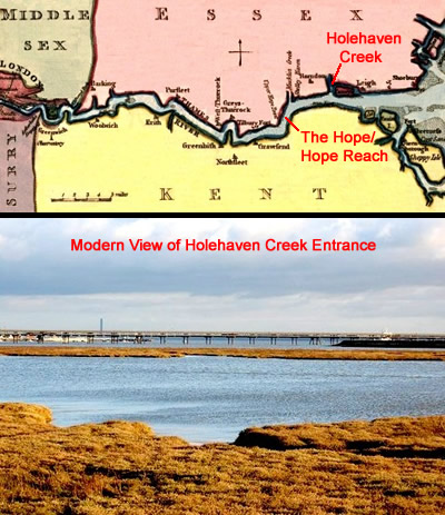
Photo: Trevor Harris; Map - John Luffman (1802)
Holehaven Creek and The Hope/Hope Reach on the Thames
The first area to be used was Holehaven Creek (1) which is referred to by Samuel Pepys in his diary as 'Hole Haven'1. This was chosen by the Lord Mayor of London. A series of letters between Lord Mayor Anthony Bateman and the Privy Council in 1663 resulted in the selection of this location. The Privy Council advised the quarantine location "should not be nearer than Tilbury Hope, and that all ships, English or foreign, coming from infected ports, should be liable to be stopped and unloaded if necessary."2 In response, the Lord Mayor suggested, "That the lazaretto should be at Moll [sic] Haven, in a creek which
would receive 100 vessels."3
Hole Haven Creek is an estuary of an Essex Creek where it joins the Thames near Canvey Island4, which about thirty-seven miles from London. Quarantine here was to be served on the arriving ships. In his reply to the Privy Council, the Lord Mayor also suggested stationing "one or more of his Majesty's ships... to examine every vessel, whether from infected places or not", along with "a guard of twenty persons or more"5 As a result, Holehaven was chosen for infected/foul ships to serve their 30 day quarantine in 1663, with "a ketch with six men would keep an eye on the detainees."6
Hole Haven was again employed 1668 when the plague broke out again in Northern France. At that time, the English sent the sloop HMS Emsworth "to the mouth of Hole Haven, to direct ships from Normandy to the quarantine station."7
Photo: John Winfield - The Lower Hope on the Thames as it Appears Today
However, Hole Haven was felt to be too small to handle the size of vessels which would require quarantine during next outbreak of communicable illness in 1692. This threat came from the Caribbean (yellow fever) and since large vessels were often used in the New World trade, the quarantine area was changed to Tilbury Hope. "The Hope or Hope Reach (2) is the stretch of the Thames between Tilbury and the mouth of the Medway. Named after the Hope stream that enters the Thames about three miles east of Tilbury."8 This is about about thirty miles from London. Here, a naval ketch and two boats from the Customs service, patrolled the shores. Being en route to London, it would seem a difficult location to maintain the necessary isolation required for effective quarantine. However, unlike Mediterranean quarantine procedures, English quarantine procedures seem to have been more focused on keeping people in suspect ships from communicating with land, not with each other. When quarantine was reinstated in 1709, the Hope was briefly considered, but eventually the queen decided "'tis too near the city and where merchantmen and others bound out and home do usually lie in great numbers", making it an ineffective quarantine location.9
1 See Samuel Pepys, The Diary of Samuel Pepys, November 26th, 1663 entry; 2,3,4 'Plague', Analytical Index to the Series of Records Known as the Remembrancia 1579-1664, W H Overall and H C Overall eds.(London, 1878), p. 349; 5 1 John Booker, Maritime Quarantine: The British Experience c. 1650 -1900, 2007, p. 4; 6 Booker, p. 7; 7 Booker, p. 10; 8 "The Hope", www.pepysdiary.com, gathered 6/24/19; 9 'Warrant Books: September 1709, 11-15', Calendar of Treasury Books, Volume 23, 1709, William A Shaw ed., 1949, p. 16
British Quarantine Locations Under the 1710 Act
English Quarantine Locations 1709-1714, Information From John Booker,
Maritime
Quarantine: The British Experience c. 1650 -1900, 2007
When the Privy Council announced that incoming ships must land only at places which provided for 40 days quarantine in 1709, they had to find locations where cargos could be removed from their ships and aired. The primary location settled upon was Stangate Creek (6) which branches off from the Medway River in the Chetney Marshes. In addition to Stangate Creek, quarantine locations established to support the 1710 Act could include other "such places as the Customs officers should
appoint."1 Among those used during this period were Harwich (3), Motherbank (4) - a shallow sandbar about eight miles from Portsmouth, Newcastle (5) and Whitebooth Road (7) which is about nine miles from Hull.
The method for choosing these sites is not clear. Researcher Peter Froggatt suggests that it was a "provision was for ships from the Baltic to quarantine at temporary sites near the large ports."2 This makes sense, although his citation is to 'an Order of 31st January, 1712' which actually recommends several quarantine locations in Scotland.3 Still, the point about the temporary nature of these sites holds true for the English Stations.
The Stangate Creek location was to be the primary quarantine site for London for the next 160 years. It branches off the Medway River, which itself branches off the Thames. Nearby Sharfleet Creek (A) was to be an overflow location with the Lower Hope in the Thames being used if
Cartographer: William Tombleson
Image Taken From Tombleson's Panoramic Map of the Thames and Medway, (1840)
Locations Discussed in Text Shown on a Map of Chetney Marshes, Thames & Medway Rivers
both of the creeks were unable to meet the capacity needs.4 The Isle of Grain (Bin the previous map), which had a wharf and warehouses was designated to serve as the airing ground for quarantined ships. Unfortunately, Lord Teynham, the owner of the wharf and warehouses, couldn't agree to terms with the Customs Commissioners, so 'a small stage and large shed' was built for airing on the creeks. It cost £2,100 to build 'stages and other conveniences' at Hoo Fort (C) and Stangate Creek. However, Booker says, "this was money wasted: the region was uninhabited because it was uninhabitable, unable to support the infrastructure of buildings, population and supply routes which a properly organized airing ground demanded."5
This was only the first of many problems with this location. Two groups of local residents did not want to risk having contagion in areas close to them and their interests.
The first group were represented in a letter from the Mayor of Rochester. He sent a petition to the Customs Commissioners in January of 1711 which was against "building houses for airing quarantine goods at a place called Hoo Fort on the Medway on the other side the water directly over against the town of Gillingham (D) about two miles from Chatham (E) and three from Rochester (F); the said towns being extremely populous and will be in great danger to receive the infection thereby."6 The mayor was asked to suggest a better location.
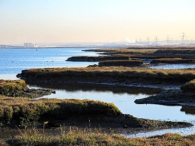
Photo: Mike Quinn - The Eastern Edge of Chetney Marshes as it Appears Today
He replied by suggesting "Stan[df]leet Creek is a more proper place than Hoo Fort whereon to erect houses for airing of goods taken out of ships that have performed quarantine."7 (This name appears to be an combination of Stangate (6) and Sharfleet Creeks.)
The second group worried about the effect of a quarantine station on their interests were oyster fishermen who worked Stangate creek. They claimed they had paid £200 to stock the area. Once it had been designated as quarantine grounds, "the ships [performing quarantine] lying on ground at low water, their anchoring there, by sweep of cables and by throwing of filth and soil out of the ship, great part of the said stock and brood [of oysters] thereof have been buried and destroyed and their fishery almost rendered useless to petitioners, whose families being upwards of 70 in number did in great measure subsist thereon"8. The Commissioners looked into this and determined that the petitioners probably laid out £150 to stock the creek and had left £300 in the creek during the winter of 1709, "most of which were destroyed. ... they assert they sustained 1,000l. loss and the ground is so much broken and full of holes that it will not be made good again in many years by reason of soft mud and slutch settling in such broken places, which will choke the oysters they lay down there"9. In late March, the Customs Commissioners paid them £250 for the previous losses with £100 a year to follow as long as the area was being used for quarantine.
In addition, there a number of people were required to enforce quarantine as well as to handle goods being brought ashore to be quarantined. This included
Artist: Joseph Mallord William Turner
Stangate Creek on the River Medway (c. 1823–4)
opening the goods, turning them so they would be fully aired, keeping each ship's cargo separate from every other one, repacking the goods when their quarantine finished and loading them back on their ship."The manpower needed for labouring, supervision and security was immense; and even this set-up would fall short of a full-scale lazaretto, as there would be no facilities for passengers or crew."10 On top of this, the marshes were ill-suited to the task. "At low tide they [the quarantine creeks] were little more than dreary mudflats among inaccessible, featureless marshlands, divided into islands on the western shore. The area was unhealthy and desolate"11.
Those standing guard sometimes worked in very difficult conditions.
The governor of Upnor Castle (G) reported to his superior: 'the places where they keep guard are two or three miles distant from each other, & as far from any house, & they are forc'd to stand in the open Marshes to do their Duty, which is so deep, that they are up to their knees, so that it is impossible for them to live, unless there be some Guard house made, or Tents provided to keep them from the Severity of the Weather'.
The reality of the situation was now becoming apparent: however useful for quarantine the Medway creeks might be, the adjacent Chetney Marshes were patently unsuitable for any purpose whatsoever.12
Information about the remaining quarantine locations is quite limited, although what there is is of some interest. These include the four quarantine sites of Harwich (3), Motherbank near Portsmouth (4), Newcastle (5) and Whitebooth Road near Hull (7).
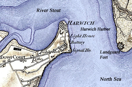
Harwich, First Ordnance Survey Map (1805); Additional Map Details Come From:
John H. Leslie,
The History of Landguard Fort, Suffolk, Frontispiece (1898)
Only one source positively identifying the Harwich quarantine location (3) was located and it is from 1915. It says that the quarantine ground is on the eastern shore of the harbor.13 Even as vague as this information is, it is probably even less useful because it was given two hundred years after the period of interest. A poem reportedly written by English humorist and playwright Tom Hood (1835-74) while he was staying near Harwich hints at a location close to Harwich as well. It says, "From filthy steps I viewed the fleet, And counted just thirteen- Four on the flood, three in the mud, And the rest in quarantine."14 This also was likely penned at least 150 years after the period of interest, based on the date of Hood's death. However, both sources do at least indicate that quarantine took place in the Harbor at Harwich at that time rather than several miles away in another location as it did at Stangate Creek. Based on the above map, it seems likely that the ships would have anchored near the Landguard Fort on the east side of Harwich Harbor. The fort could then be used to monitor those serving quarantine.
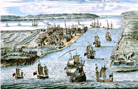
Artist: Johannes Kip - A Prospect of the Harbor at Harwich (c. 1725-50)
Booker explains the administrative details of quarantine as performed here:
The procedure at Harwich was straightforward, and representative of the wider system: when a ship arrived from a port suspected of infection, she was immediately put under quarantine. The collector, every day if necessary, wrote to the Board in London with a list of arrivals; he gave ships' and masters' names, and brief details of cargo and provenance. He wrote again when the period of 40 days had elapsed, confirming that the master and others had gone ashore to make their sworn declarations, and that crewmen were free of infection.15
He also mentions that the ships anchored in the harbor and simply opened their hatches if the weather permitting.16 Harwich apparently had no airing ground for goods.
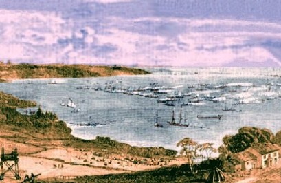
Motherbank (4) is a sandbar off of the Isle of Wight which is conveniently located near Portsmouth as well as Spithead and Southampton. Here again there were no facilities for airing goods so, like Harwich, ships would anchor there and open their hatches for the quarantine period.
 Cartographer: John Thomson Motherbank Sandbar Location, From Remote British Isles (1817) |
 Artist: Richard Leich A Flotilla of Gun-Boats Off Motherbank, Illustrated London News, 5-3-1856, p. 469 |
An account of the history of York (the northern land mass in this image, referred to on the map as Yorkshire) gives a very brief account of quarantine at Whitebooth Road as early as the mid-17th century
...in the early 1660s, when plague raged in various parts of England and the Continent, quarantine measures were strictly enforced in Hull, especially against ships from London, Holland, and France. Vessels were obliged to stand out in the roads for 40 days, while anyone landing from them was shut up for a similar period. Means were devised to unload perishables: catches were tied to the dolphin [a bollard, pile, or buoy for mooring boats] in the mouth of the River Hull, whence they were taken by the crews to their ships, loaded, and returned to the dolphin to await collection. Even when ships were released from quarantine their cargoes were aired in the catches [ketches - small boats] before being landed.17
Although this refers to a form of localized quarantine during a period before national quarantine was implemented in England, it seems to accurately reflect the sort of quarantine that Booker identifies in his book.
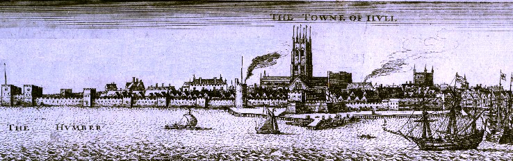 Artist: Wencelas Hollar - The Town of Hull Seen From the River Humber (17th century) |
Of these four locations which came into use in the 1709-1714 period, Newcastle (5) is the one about which the least information was found. It is not entirely clear where ships under quarantine even anchored. The English Secretary to the Treasury sent a letter to Secretary of the Admiralty Josiah Burchett in 1709 asking about some navy men from HMS Fox who boarded "a ship under quarantine in Newcastle harbour under pretence of pressing men", which caused the ship's crew to go ashore.18 From this report, it can be seen that quarantine occurred in 'the harbor' outside of Newcastle. (Because of his transgression, the captain of the Fox was sent a letter of disapproval, although no other action was taken.19) As seen in the map below, Newcastle has quite a small harbor and would seem to have provided a lot of opportunity for those in quarantine to come in contact with those who were not. Of this quarantine site, Booker only says, "At Newcastle, airing [of goods] was the subject of an early and deep division between collector and corporation which led to Privy Council intervention. The collector was given the last word, but there is no reason to believe that an airing ground was ever established"20.
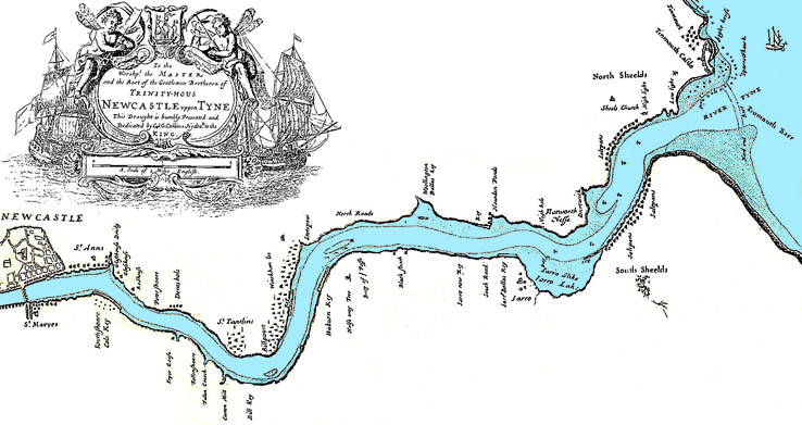 Cartographers: William Mount and Thomas Page - Newcastle Uppon Tyne, Map of the River Tyne (1738) |
Quarantine at Hull during the golden age of piracy occurred in Whitebooth Road in the Humber River (7). Booker found evidence of 'Airy Sheds' being located on land by January 1710.21 He suggests that they may not have been there much longer. The British Magazine reported in July of 1783 that "all such goods as shall be imported to the ports of Ipswich, 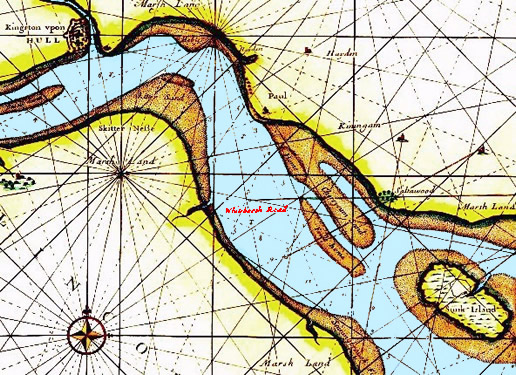
Harwich, First Ordnance Survey Map (1805); Additional Map Details Come From:
John H. Leslie,
The History of Landguard Fort, Suffolk, Frontispiece (1898) Yarmouth, Lynn, Boston, Mull, Newcastle, or Berwick upon Tweed, or any of them, or any member or creek thereof, or other place therein, shall be aired in Whitebooth Road, between Hull and Grimsby"22. Of course, this only indicates that goods were aired there, not whether they were aired on their vessels or on land.
Former navy ship captain Greenville Collins was appointed by King Charles II to survey England's coasts and draw up improved nautical charts, which he began in 1681. One of his surveys included a map of the Humber River which includes both (Kingston upon) Hull and Whitebooth Road. The relevant section of this map is seen at left. In this part of the map, Kingston upon Hull appears in the upper left corner and Whitebooth Road appears near the center in red lettering. Sandy areas are shown in brownish-tan while marshy areas have a yellow hue. The blue part passing from the lower right hand corner to the upper right represents the "road" or the navigable channel through the River Humber.
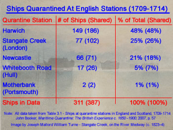
Something Booker discusses in some detail is the number of ships which served quarantine at the various locations established for this period. He provides a table showing how many ships served quarantine at the various stations in use during this period. His table is complicated somewhat by the fact that some ships served part of their quarantine in one location, then moved to another closer to their destination. So some ships are counted twice in the data. For
Artist: Joseph Mallord William Turner
Stangate Creek on the River Medway (c. 1823–4)
simplicity, the ships serving quarantine in only one location are shown regularly with the total number of ships (including those that were counted more than once because they served in more than one location) shown in parenthesis. This data can be seen in the table at right. The numbers as a percentage of the total are very similar with or without the data for ships serving at more than one port. It must also be noted that this data is incomplete. Booker warns: "These are known ships at known quarantine station, not definitive totals."23
Being so close to London as well as half-way between the ports on the eastern and southern costs of England where much of the demand for naval stores, Stangate Creek would seem like the most logical place for ships to serve quarantine. However, the War of Spanish Succession flooding during the winter "conspired to make Stangate Creek less useful than it should have been."24 As a result, the most popular quarantine station in England during this period is Harwich, garnering almost half the quarantined ships. Booker notes that this was likely because a ship might not sail directly for London during the war. "Harwich was well placed geographically to receive and dispatch convoys: not only was the North Sea journey relatively short, but the Thames was within easy reach, and coastwise convoys could escort northbound ships to Hull, Newcastle and intermediate ports."25
Stangate Creek, for all its faults as a quarantine location, was still the second most-used station, hosting approximately a quarter of ships in the data. Most of the rest quarantined in Newcastle with Hull and Portsmouth combined serving less than ten percent of the quarantined ships according to this data.
1 John Booker, Maritime Quarantine: The British Experience c. 1650 -1900, 2007, p. 35; 2 Peter Froggatt, "The Chetney Hill Lazaret", Archaeologia Cantiana, Vol. 79 (1964), p. 3; 3 Calendar of Treasury Books, 1712, Vol XXVI (Part. 2), p. 101 - For the record, these include: "Inverkeithing Bay, for ships bound to any place within the Firth of Forth, the Tay, opposite to Bructy [Broughty] Castle, for ships bound to Dundee, Perth, Montrose and Aberdeen, Cromarty Firth, for ships bound to Inverness and all the north, the Tail of the Bank, for ships bound to Port Glasgow, Irwin and Campbeltown, Lochryan, for all ships bound to Ayr, Portpatric and Wigtown, Carsthorne [Carsphairn], for all ships bound to Dumfries and Kirkcudbright. If only the English choices were made so clear; 4 Booker, p. 31; 5 Booker, p. 32; 6 'Warrant Book: January 1711, 22-31', Calendar of Treasury Books, Volume 25, 1711, William Shaw, ed., 1952, p. 137; 7 'Warrant Book: February 1711, 21-24', Calendar of Treasury Books, Volume 25, 1711, William Shaw ed., 1952, p. 177; 8,9 'Warrant Book: March 1712, 26-31', Calendar of Treasury Books, Volume 26, 1712, William Shaw ed, 1954, p. 217; 10 Booker, p. 32; 11 Booker, p. 31; 12 Booker, p. 34;13 U.S. Hydrographic Office, British Islands Pilot, Vol VII, 2nd ed., 1915, p. 355; 14 J J. Raven, East Anglian: or, Notes and queries on subjects connected with the counties of Suffolk, Cambridge, Essex and Norfolk, Vol. 8, Jan 1900, p. 103; 15 Booker, p. 58; 16 Booker, p. 59; 17 'Hull in the 16th and 17th centuries', in A History of the County of York East Riding: Volume 1, The City of Kingston Upon Hull, K. J. Allison, ed., 1969, Retrieved from British History Online 6/27/19; 18 His Majesty's Stationery Office, Calendar of Treasury Books, Volume 23, 1709, 1949, p. 462-3; 19 Booker, p. 49; 20,21 Booker, p. 59; 22 W. Wood, The British Magazine and Review, Or, Universal Miscellany, Volume 3, 1783, p. 70; 23 Booker, p. 57; 24,25 Booker, p. 56
British Quarantine Locations Under the 1720 Act
When the 1720 act requiring quarantine was established, the Customs Commissioners, who were in charge of quarantining ships,

English Quarantine Locations 1720-1723, Information From John Booker,
Maritime
Quarantine: The British Experience c. 1650 -1900, 2007
recommended that ships serve their quarantine "at London (6) or Bristol (8), and the intervening ports of Falmouth (9), Plymouth (10) and Portsmouth (4). The Privy Council were evidently reluctant and asked the Admiralty to comment"1. However, they eventually "conceded that the quarantine ports were now London, Portsmouth, Plymouth, Falmouth and Bristol, and airing grounds were to be summarily appointed by local Customs."2
Because of the fear of the plague at Marseille, the procedures at quarantine sites were better defined for this period. Transgressions were explicitly mentioned and their fines and punishments were strengthened. However, as with the 1710 quarantine locations, no provisions were made to quarantine passengers on shore.3 As mentioned, the possibility of constructing a lazaretto was also mentioned in the act: "In Times of Infestion the King may cause Ships and Lazarets to be provided for the Performance of Quarentine, Quarentine, and Entertainment of Persons infested, likewise proper Places for airing of Goods, &c."4 However, since England was never infected while the act was in place, no lazarettos were built. The issue of airing goods was also addressed later in the Act. "After Quarantine, Goods &c. shall be opened and aired as his Majesty shall direct; and on Proof thereof such shall be discharged."5
The London quarantine grounds continued to be in the Chetney marshes (6), moving the location back to Hoo Fort. Historian John Booker says the the Privy Council "set about risking another rumpus with Rochester by building airing sheds on Hoo Fort Island (C in the graphic at the top of the previous section)."6 The island is located in Medway River across from Stangate Creek. The governor of nearby Upnor Castle (G in the graphic in the previous section), was recruited "to 'watch' the sheds being erected on Hoo Fort Island."7 The Privy Council instructed the Lord Mayor of London "to appoint 'knowing' persons to open, air and repack goods after quarantine."8
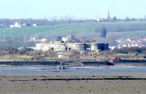
Photo: Clem Rutter - Hoo Fort Island as It Appears Today, with the Town Hoo St. Werbergh Behind It
The London-based Levant Company which traded with the suspect Ottoman empire, complained that these quarantine facilities consisted of "only open Boarded Sheds on a small Island [Hoo Fort], in ye River Medway, a great distance from home, which have been twice overflown by the Tides'."9 This flooding occurred because the water in the Thames increased, which "in the winter becomes such a torrent as to overflow the meadows for many miles around."10 The Levant Company explained that in such a location silk would lose its' sheen from being exposed to dampness and the air when opened and the bale marks used to identify the different products and owners would be confused when the bales were opened and the material was removed to insure effective airing.
The oyster fisherman who had complained about the ships serving quarantine ruining their planted oyster beds in 1710 again sent a petition to the government. It complained that they "had restocked their oyster beds around Stangate Creek 'at great expense', following the cessation of quarantine in 1714."11 Quarantine measures again prohibited them from using the creek. Further, they were told that when people died while in quarantine, "the Dead Bodys are to be put into a Chest and flung over into the said oyster Grounds"12. Such complaints don't appear to have moved the English government who proceeded to make Hoo Fort Island into London's quarantine station.
Similar to the quarantine locations used in 1710, there is scant information about other quarantine sites of Portsmouth (4), Bristol (8), Falmouth (9) and Plymouth (10). However, it is worth reviewing what does exist.
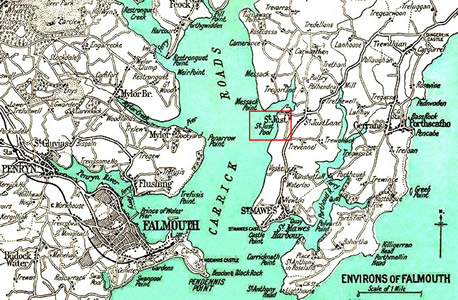
St. Just's Pool (In Red Box), Falmouth Area Ordnance Survey Map (1948)
What is known about quarantine at Portsmouth (4) was covered in the previous section while discussing the Motherbank Sandbar.
Near to Portsmouth was a new quarantine location by Falmouth located at St. Just's Pool (9). This was located "within the mouth of the harbor of Falmouth"13. In the late 18th century, it was described in one guide as "the best place in all the [Falmouth] harbour for anchoring; but ships cannot sail from it as conveniently as Carreg [Carrick] road"14.
Booker says that he found little evidence of ships performing quarantine at Falmouth during this period in the official records. However, he notes that such "information as to quarantine ports in the registers is occasional and haphazard, and may give the wrong impression."15 He highlights this comment with an example from another port. "Only two ships, for example, were noted as quarantined in Bristol, whereas the real number would have been second only to London."16
It is not clear where the quarantine area was for Bristol (8). In 1772, almost fifty years after this period, a quarantine area was established in King Road (shown in the red ellipse in the map seen below) where ships with clean bills of health could serve quarantine for ports which included Bristol.17 This is located about 8 or 9 miles from town by water. However, there is no indication that this location was used for quarantine in 1720.
The suggestion of a closer quarantine location can be found in two letters written by the Society of Merchant Venturers of Bristol complaining about the the 1720 act. These noted a lack of proper facilities at Bristol for proper goods quarantine. The first letter, sent November 15th, explains that because of the
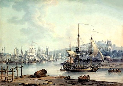
Artist: Nichola Pocock - Bristol Harbor (1785) [wikigalleries.com - Not for Commercial Use]
'great flux of water of not less than nine fathoms' in the spring, "the ground is so soft and owsey [oozy] and the banks so steep that it is not possible to build a wharfe on which a crane may be erected to land ponderous goods and, were it otherwise, the ground adjoining to the river is so marshy and low that it is often overflown... so that goods are not fit to remain there when landed."18 The Society requested permission "to putt the goods into lighters or vessells out of the ships [they arrived in], ...to be aired in the same lighters [flat-bottomed boats] during the time appointed by your majestie's proclamation, and that then the goods may be permitted to be brought in the same lighters or vessells to their place of discharge [on land]."19
This did not receive a response, so the Society sent a second letter on December 2nd. This letter stated "our river is such that there are no places convenient for landing goods but at the proper keys and wharfes within our port."20 It asked that goods not subject to quarantine and ships coming from places which were not infected with the plague be allowed to unload goods after they performed quarantine. Booker explains, "The Privy Council referred this [the Merchant Venturer's complaint] to the Treasury as usual, but the Customs report was favourable and the Bristolians, at least, won their day."20 While the exact location the Society is discussing is still not clear, it reference to 'keys and wharfes within our port' suggests Bristol Harbor was the quarantine location rather than King Road.
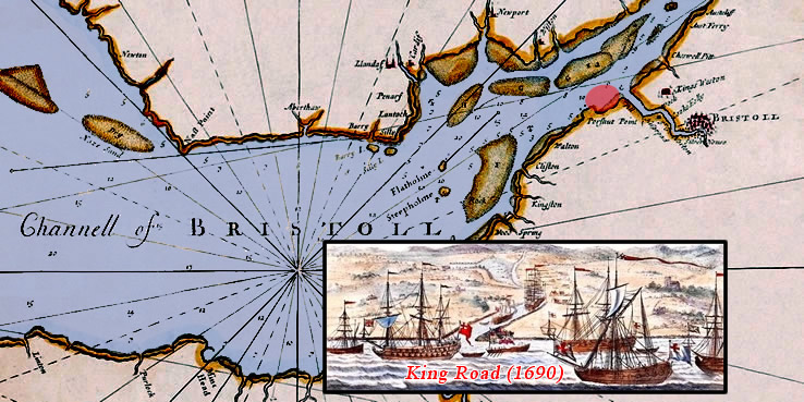 Cartographer: Grenville Collins Map of Bristol Channel With King Road Shown in Red Ellipse & Inset Image of King Sailing to King Road, From Great Britain's Coasting Pilot (1723) |
As with the Newcastle quarantine location in 1710, very little information is found concerning the quarantine location at Plymouth (10) during this period. Booker found evidence that 'hoys' - referring to flat-bottomed barges like lighters - were used at Plymouth during this period, again indicating that a land-based quarantine site was not established.21 He also explains that Plymouth was the most popular port on the southern coast of England for quarantine during this period, although this conclusion is based on a small, incomplete set of data and cannot be be considered a proxy for the real popularity of quarantine sites at this time.22 Nor is it clear where in the Plymouth Sound that quarantine was performed, although there are a variety of potential locations certainly existed, as seen in the map below right.
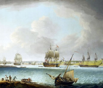 Artist: Dominic Serres the Elder - Men of War at Plymouth (1766) |
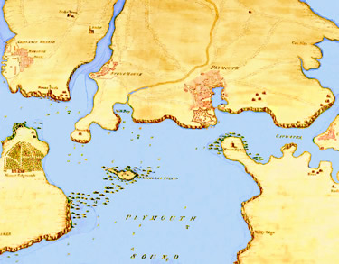 Plymouth Sound Map (1720) |
1,2 John Booker, Maritime Quarantine The British Experience c. 1650-1900, 2007, p. 94; 3 Booker, p. 107; 4 Great Britain and Owen Ruffhead, Statutes at Large, Vol. 5, (1714-1728), 1763, p. 330; 5 Great Britain..., p. 331; 6 Booker, p. 94; 7 Booker, p. 100; 8 Booker, p. 101; 9 Booker, p. 106; 10 'Canal', Encyclopaedia Londinensis, Vol. 3, John Wilkes ed., p. 677; 11,12 Booker, p. 101; 13 The London Gazette, Tuesday, August 9 1825; 14 John Chandler, John Adams & John Diston, The Seaman's Guide and New Coaster's Companion, 1795, p. 35; 15,16 Booker, p. 119; 17 W. Wood, The British Magazine and Review, Or, Universal Miscellany, Volume 3, 1783, p. 70; 18 Society of Merchant Venturers, Politics and the Port of Bristol in the Eighteenth Century: The Petitions of the Society of Merchant Venturers, 1698-1803, Volume 23, 1963, p. 10; 19.20 Society of Merchant Venturers, p. 11; 20 Booker, p. 101; 21 Booker, p. 113; 22 Booker, p. 118-9
Plague Quarantine Page Menu: 1 2 3 4 5 6 7 8 9 10 11 12 13 14 15 <<First
Main Page • Tools & Procedures • Miscellanea • About the Author • Facebook Page
All original content copyright M. Kehoe • 2003-